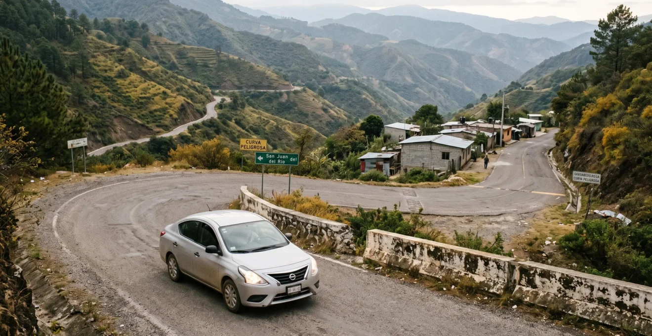
A hundred miles on a relatively straight Mexican highway can feel like an ordinary motorway journey. Cover the same distance through the mountains of Oaxaca, Chiapas or Chihuahua, and the driving experience changes completely. Hairpin bends, steep gradients, village crossings and occasional damaged road surfaces can turn a short-looking route into most of a day’s travel.
The distinction matters particularly to British travellers accustomed to estimating journeys from motorway mileage. In Mexico, geographical distance alone says remarkably little about how long a drive will take. Road classification, elevation changes, weather, traffic and the availability of alternative routes can matter more than the number of miles.
The contrast between 90 minutes and four hours is an illustration, not a universal speed rule. Understanding why such differences are possible helps you judge navigation estimates, decide when a toll highway is worthwhile and identify destinations that are physically accessible without demanding mountain driving.
A successful Mexican road trip begins with one question: not simply how far is the destination, but what kind of terrain must be crossed to reach it?
Mexico driving times: what matters most
- Terrain changes travel time: straight, well-maintained highways and steep, winding mountain roads require entirely different driving assumptions.
- Verify the road, not just the route: check surface conditions, official advisories, weather and vehicle suitability before committing to remote journeys.
- Protect daylight and recovery time: use major highways for longer transfers and treat mountain viewpoints as slower, dedicated excursions.
- Why Does Google Maps Keep Getting Mexican Drive Times Wrong by 30% or More?
- How to Check if a Mexican Road Is Safe to Drive Before Committing Your Itinerary
- Which Is Smarter for First-Timers: Toll Roads or Scenic Mountain Routes in Mexico?
- The Mountain Road Mistake That Puts Rental Cars on Edges They Weren’t Built For
- When Should You Tackle Mountain Roads in Mexico to Avoid Fatigue and Darkness?
- The Itinerary Mistake That Turns a Dream Mexico Trip Into 5 Exhausting Transit Days
- How to Plan a Canyon Viewpoint Day With Fewer Hairpin Bends and Better Breaks?
- Which Mexican Canyon Viewpoints Are Worth It if You Get Motion Sickness Easily?
Why Does Google Maps Keep Getting Mexican Drive Times Wrong by 30% or More?
Google Maps driving estimates can become unreliable on some Mexican mountain routes because changing road conditions, low speeds through villages and complex terrain are difficult to predict consistently. However, there is no established evidence that the app systematically underestimates Mexican journeys by 30% or more. The sensible approach is to treat mountain-route estimates as provisional rather than guaranteed arrival times.
Navigation software estimates journey times using information such as mapped road characteristics and available traffic data. It does not simply assume that every road operates at motorway speeds. Nevertheless, an estimated average speed may fail to reflect the practical challenges of a particular journey, especially where real-time traffic information is limited or conditions change suddenly.
Consider three contrasting environments:
- Yucatán Peninsula: relatively flat terrain and straightforward highway sections can make journeys easier to estimate, although settlements, speed restrictions and roadworks still cause delays.
- Bajío region: established highway corridors may allow relatively consistent progress when traffic and road conditions are favourable.
- Oaxaca, Chiapas and Copper Canyon: mountainous geography introduces elevation changes, successive bends and potentially slower secondary roads.
Mexican speed bumps, known as topes, add another variable. Repeatedly slowing down through populated areas can reduce the average speed of a journey even where the road appears fairly direct on a map.
Rather than automatically adding 30% to every estimate, assess the journey by road category, settlement density and elevation profile. A mountainous route passing through several towns deserves more contingency time than a comparable distance on a major highway.
Think also about the consequences of arriving late. A modest delay may be manageable on an ordinary sightseeing day but expensive when followed by a timed tour, ferry departure or non-refundable transfer.
Hypothetical example: one distance, two journeys
Imagine two journeys of approximately 100 miles. On a clear, fast highway, an illustrative 90-minute journey assumes sustained progress with few interruptions. On a winding mountain route averaging roughly 25 mph, the same distance would take approximately four hours before additional stops.
These are mathematical scenarios, not measured Mexican route speeds. They demonstrate why distance is a poor substitute for examining the actual road.
Navigation estimates are useful starting points. The mistake is converting them into tightly linked reservations without allowing for the physical geography between destinations.
How to Check if a Mexican Road Is Safe to Drive Before Committing Your Itinerary
Check a Mexican road by separating its physical condition from its security situation. Verify recent highway notices, weather warnings, route classification and regional travel advice, then compare these with recent first-hand reports. If reliable information is missing, avoid making an uncertain remote road essential to your itinerary.
Road safety has two separate dimensions. The first concerns the road itself: potholes, damaged surfaces, landslides, flooding, visibility and whether an ordinary car can negotiate the route. The second concerns regional security, including crime-related risks, official travel restrictions and the reliability of assistance.
A road may be physically smooth but subject to serious security concerns. Conversely, an area without a specific security warning may still contain unsuitable mountain tracks.
The U.S. Department of State’s Mexico travel advisory distinguishes regional travel risks and warns that road maintenance and access to emergency assistance vary across Mexico. Its recommendations include favouring toll roads and making intercity journeys during daylight hours.
For highway conditions, the Mexican federal toll-road operator CAPUFE identifies CAPUFE’s official road-information and assistance channels, including its 074 information number for roads it operates. These channels can help with weather, traffic incidents and route information, but they do not cover every Mexican road.
For other roads, consult the relevant transport authority, including SICT information where applicable, and regional civil-protection notices. Recent posts from local drivers may provide useful clues about closures or damage, but should be corroborated rather than treated as official confirmation.
Satellite imagery can help identify road width, settlement patterns and visible unpaved sections. It cannot prove that the surface remains passable today: images may predate storms, landslides or roadworks.
Seasonality is crucial. Rainy-season conditions affect different regions at different times. Heavy rainfall can make a road that was manageable in dry weather temporarily dangerous or impassable. Check current local forecasts rather than assuming that every part of Mexico shares the same rainfall calendar.
Five checks before confirming a remote Mexican drive
- Identify the exact route: save the road numbers and alternative routes, producing a clear route outline.
- Check official alerts: record any relevant road closures, weather notices or regional restrictions, with their publication dates.
- Inspect the surface: review mapping imagery and obtain current confirmation where possible, noting any uncertain or unpaved sections.
- Confirm vehicle suitability: check the rental agreement and road classification, recording any restrictions on unpaved driving.
- Document a fallback: save an alternative route and the decision point at which the original journey will be abandoned.
When conditions cannot be verified, choose a better-established route or postpone the excursion. Uncertainty should affect the itinerary before it becomes a roadside problem.
Which Is Smarter for First-Timers: Toll Roads or Scenic Mountain Routes in Mexico?
For first-time visitors, toll highways are generally the more practical choice for longer transfers where an appropriate route exists. Scenic free roads make better sense when the drive itself is a planned activity, conditions are confirmed and adequate daylight remains. The decision should balance money, travel time and driving workload rather than toll price alone.
Mexican toll highways are commonly called cuotas, while free roads are known as libres. Toll-road design and operating conditions vary, so paying a toll does not guarantee a straight, fast or risk-free journey.
Still, a well-maintained major highway can reduce the demands associated with repeated village crossings and narrow mountain bends.
The distinction becomes clearer when comparing the practical costs of each option.
| Decision factor | Toll highway (cuota) | Free or scenic road (libre) |
|---|---|---|
| Direct road cost | Tolls apply | No toll for the free route |
| Journey predictability | Often preferable on established corridors | May vary substantially with villages, terrain and conditions |
| Driving workload | Potentially lower on suitable major highways | Can increase with bends, crossings and changing surfaces |
| Sightseeing value | Useful primarily for efficient transit | Can offer access to smaller settlements and viewpoints |
| Best application | Longer transfers and time-sensitive journeys | Short, verified daytime sightseeing sections |
Consider the purpose of the day. If the objective is to reach accommodation in another region, efficient transit deserves priority. If the objective is to explore a particular mountain landscape, spending more time on a suitable scenic road may be worthwhile.
Previous driving days matter too. After several demanding transfers, the extra concentration required by a mountain route may have a greater cost than the toll you would save.
A hybrid itinerary often works best: use major highways between regional bases, then make shorter excursions onto verified scenic roads. This preserves access to landscape and local culture without making every transfer physically demanding.
Check the intended vehicle as well. A compact rental car may suit paved highways but be inappropriate for rough access roads, regardless of how attractive the destination appears on a map.
Free roads do not eliminate travel costs. Extra driving time, fuel use, unpredictability and fatigue also belong in the calculation, even when they do not appear on a receipt.
The Mountain Road Mistake That Puts Rental Cars on Edges They Weren’t Built For
The dangerous mistake is selecting a mountain shortcut or scenic destination without verifying road classification and vehicle suitability. A navigation app may propose a technically connected route that includes narrow, steep or unpaved sections. An ordinary rental sedan may lack the clearance, tyres or contractual permission needed for such a journey.
Road accessibility and destination accessibility are not identical. A remote village or canyon floor may be reachable by a vehicle operated by experienced local drivers without being appropriate for an unfamiliar visitor in a low-clearance hire car.
Mountain roads can deteriorate gradually. A reasonably surfaced approach may become a narrow track with exposed edges, loose stones or deep ruts. By the time the unsuitable section is obvious, turning around may be difficult.
That is why the decision belongs at the planning stage rather than at the edge of a steep descent.
Rental agreements deserve particular attention. Restrictions on unpaved roads, vehicle misuse or driving outside authorised areas vary by provider and contract. Coverage may be limited or excluded under particular circumstances, but no universal rule applies to every Mexican rental.
Before departure, obtain written clarification about the specific route or road type if the terms are unclear. Paying for additional cover does not automatically authorise driving on otherwise prohibited roads.
Warning signs that should prompt reassessment include:
- A paved surface ending before a steep or remote section.
- Deep ruts, unstable edges or obstacles that threaten the underside of the vehicle.
- Road width that leaves little room to pass oncoming traffic.
- Severe gradients combined with poor visibility or inadequate stopping space.
- Local advice indicating that high-clearance or specialised vehicles are normally required.
None of these factors should encourage a risky manoeuvre. If the road appears unsuitable, stop in a safe location and assess whether retreat is possible without creating further danger. Do not continue simply because the destination looks close on the map.
For canyon floors or isolated mountain communities, locally operated transport may be preferable. A professional driver familiar with the route can provide appropriate local knowledge and, where available, a suitable vehicle. Verify the operator and the current route conditions before booking.
Getting closer to a destination is not progress if the road becomes inappropriate for the vehicle. Sometimes the sensible endpoint for a self-drive excursion is a viewpoint above the destination, not the remote road below it.
When Should You Tackle Mountain Roads in Mexico to Avoid Fatigue and Darkness?
Plan unfamiliar Mexican mountain drives to finish well before sunset, with enough daylight remaining for unexpected delays. Earlier departures usually provide greater flexibility, but the ideal window depends on weather, route direction, visibility and current road conditions. Daylight driving is a strong precaution for intercity travel, not a universal legal requirement.
Mountain driving becomes more demanding after dark because bends, damaged surfaces, animals, obstacles and road edges can be harder to detect. Some routes also have limited artificial lighting or unreliable communications coverage.
Fog creates an additional hazard, potentially reducing visibility on elevated sections even during daylight. Morning conditions are not automatically better: local forecasts and the particular mountain range should guide timing.
A more reliable scheduling method begins at the intended arrival time and works backwards.
- Check sunset for the specific destination and travel date.
- Identify which part of the route passes through the most demanding mountain terrain.
- Allow time for planned breaks, village crossings and possible road delays.
- Choose a departure that leaves a daylight reserve after the mountain section.
- Establish a safe alternative stopping point if the journey progresses more slowly than expected.
The amount of extra time should reflect the road and the uncertainty involved. A fixed buffer cannot guarantee arrival because unexpected closures or weather changes may exceed it.
Fatigue also deserves attention. A long motorway journey allows relatively consistent driving demands, while mountain roads require continuous adjustments for steering, braking, visibility and approaching traffic.
Climbing and descending are different tasks. A descent may require more careful speed management, while a climb may introduce slow-moving vehicles and limited overtaking opportunities. Fog, sunlight and exposure can also differ by direction.
Drivers unfamiliar with steep descents should understand appropriate engine braking and follow the vehicle manufacturer’s instructions. Continuous heavy braking on a prolonged downhill section can create additional mechanical risks.
Allowing the most demanding drive to occupy a dedicated morning or early part of the day can make a journey easier to manage, provided local conditions support that choice.
A route that cannot reasonably be completed in daylight may need an overnight stop. The itinerary should adapt to the mountain, not force the mountain journey into an already crowded day.
The Itinerary Mistake That Turns a Dream Mexico Trip Into 5 Exhausting Transit Days
The most common planning error is treating Mexican destinations as interchangeable points on a distance map. A journey that appears manageable across flatter regions may require substantially more effort through mountainous terrain. When several optimistic travel estimates are combined, an attractive multi-stop holiday can become a sequence of tiring transfer days.
For travellers with limited annual leave, the temptation is understandable. Mexico offers archaeological sites, cities, coastlines, forests and dramatic mountain scenery, often within the same broad travel plan.
But combining appealing destinations does not guarantee a practical route between them. The road network follows geographical constraints, and some journeys require detours around mountain ranges rather than direct movement across them.
Audit the itinerary before booking accommodation.
First, list every transfer between overnight bases, including any airport journeys or excursions involving substantial travel. Next, label the terrain and road type for each section, distinguishing major highways from demanding mountain roads.
Then replace overly optimistic assumptions with cautious planning allowances based on the specific route and current information. Compare the resulting travel commitments with your personal tolerance for driving.
For example, a hypothetical itinerary may contain five transfer days that initially look modest because each destination seems geographically close to the next. Once mountain conditions, meal stops and recovery periods are included, those days may absorb far more of the holiday than anticipated.
The problem can compound. A delayed arrival may lead to reduced sleep, a later departure the following morning and a renewed attempt to recover lost time. In mountain country, that pressure can push a demanding drive towards dusk.
Cluster destinations geographically and topographically. Rather than moving between distant regions every day or two, establish a base and explore nearby places that share practical access routes.
One base might support several cultural visits, another a slower mountain excursion and a third time on the coast. The particular locations depend on security advice, season and transport options, but the principle remains consistent: fewer major transfers create more time for the places themselves.
It may also be worth separating journeys by mode. A suitable intercity flight or established long-distance transport service can sometimes replace an exhausting road transfer, though schedules and onward connections must be checked.
A memorable Mexico itinerary is not measured by how many regions it includes. It is measured partly by how much time remains to experience them once the driving is finished.
How to Plan a Canyon Viewpoint Day With Fewer Hairpin Bends and Better Breaks?
Plan a canyon viewpoint day around accessible rim locations rather than automatically descending towards the canyon floor. Identify two or three viewpoints with verified approaches, nearby facilities and suitable parking or transport connections. This reduces unnecessary driving and creates natural breaks, although some rim approaches still involve winding mountain roads.
The distinction between a canyon rim and a canyon floor is fundamental. Reaching a viewpoint above a canyon may require a manageable approach along an established tourist corridor, while descending towards settlements below can involve a much longer sequence of steep bends.
In Chihuahua’s Copper Canyon region, Divisadero provides an example of a destination where visitors can experience extensive canyon scenery without necessarily driving down to the bottom.
The railway operator’s Chepe Express Divisadero attractions page describes established viewpoints, walking activities and a cable car at Parque de Aventura Barrancas del Cobre.
These attractions offer ways of appreciating the landscape from the tourist area, subject to access conditions and current operating arrangements. They do not establish that every approach road to Divisadero is easy, straight or suitable for every traveller.
Before choosing viewpoints, inspect the entire approach rather than the final few metres. Look at the road profile, identify major descents and confirm whether the destination requires rough-road access or a local transfer.
A practical day can revolve around an initial viewpoint, a longer stop with food and facilities, and one final panorama if daylight and energy permit. Confirm which facilities actually operate on the intended date rather than assuming every mirador has services.
Scheduled breaks also help drivers regain concentration. Stopping at a safe, designated parking area is preferable to improvising a roadside halt on a narrow mountain bend.
If the party includes travellers who become uncomfortable on winding roads, select viewpoints using the approach profile as a primary criterion. The most famous panorama is not automatically the most suitable one.
A canyon day should leave time to look at the canyon. Treating every viewpoint as another waypoint on a long transfer undermines the purpose of the journey.
Key takeaways before choosing your canyon viewpoints
- Assess the road approaching each viewpoint, not just the altitude or the attraction’s name.
- Prioritise established rim access and transport options when winding roads cause discomfort.
- Keep a simpler alternative available so different travellers can enjoy the landscape without undertaking identical journeys.
Which Mexican Canyon Viewpoints Are Worth It if You Get Motion Sickness Easily?
For travellers prone to motion sickness, established canyon-rim viewpoints with shorter, less winding approaches are usually more suitable than destinations requiring lengthy descents. Divisadero in the Copper Canyon area is worth considering, especially when reached through an appropriate transport connection. However, no Mexican canyon viewpoint can be guaranteed to provide a nausea-free journey.
Motion sickness is influenced by the relationship between movement sensed by the inner ear and information received through the eyes. Repeated bends and changes in direction can increase discomfort, but susceptibility differs considerably between people.
The CDC Yellow Book chapter on motion sickness explains that looking towards the horizon, avoiding reading and maintaining a useful forward visual reference may help reduce symptoms. These measures offer partial protection rather than a guaranteed solution.
For Mexico, this suggests evaluating viewpoints according to how you reach them, not ranking them solely by scenic reputation.
| Experience | Potential advantage | Important limitation |
|---|---|---|
| Divisadero rim viewpoints | Established canyon viewing area without a necessary road descent to the canyon floor | Road approaches and local transfers must still be assessed |
| Divisadero using a suitable rail connection | Can avoid some self-drive mountain sections | Train movement can also cause motion sickness; schedules require confirmation |
| Established plateau-edge or desert-canyon lookouts | May offer gentler approaches where access roads are relatively direct | No destination is automatically suitable without checking the actual route |
| Deep canyon-floor excursions | Offer a different perspective within canyon landscapes | May require prolonged winding descents and demanding returns |
Divisadero is particularly relevant because its canyon views and tourist facilities allow visitors to enjoy the wider landscape without necessarily undertaking a road descent. Cable-car and walking options may also diversify the experience, although their suitability, accessibility and operating status require confirmation.
For unavoidable winding journeys, practical adjustments can help. Sitting in a position with a clear forward view, looking towards the horizon and avoiding reading or using a phone may reduce sensory conflict. Being the driver can help some individuals, but only when they are fit to drive and comfortable with the conditions.
Avoid beginning a difficult journey while sleep-deprived. Food-related strategies vary between individuals; a heavy meal may feel unpleasant for some passengers, but dietary changes are not a reliably proven preventive treatment.
Anyone considering motion-sickness medication should seek appropriate medical or pharmacy advice, particularly before driving. Some medicines cause drowsiness and are unsuitable for drivers.
Split the group’s activities when necessary. One traveller may prefer remaining at an accessible rim viewpoint while others undertake a more demanding excursion. A prearranged meeting point can preserve shared sightseeing without forcing everyone onto the same road.
That strategy requires attention to the surroundings. Confirm transport, opening hours, safe waiting facilities and reliable communication before separating, particularly in remote areas.
Travellers who are highly sensitive to bends should also consider whether the outward and return journeys will be equally manageable. A spectacular viewpoint can still be a poor choice if reaching it requires several hours of uncomfortable travel.
Choose one canyon destination, verify its access route and compare it with your group’s tolerance before reserving transport or accommodation. The objective is to enjoy Mexico’s extraordinary landscapes without turning the journey towards them into the hardest part of the holiday.
Is 100 miles a long drive in Mexico?
It depends on the route. A hundred miles on a major highway can be a straightforward transfer, while the same distance across winding mountain roads may require several hours. Check road classification, elevation changes, settlements, current conditions and available daylight before assessing the journey.
Does the letter D on a Mexican road number mean it is a toll road?
Mexican federal toll routes commonly use a D suffix, such as a numbered road shown with D on mapping or signage. Confirm the exact route and applicable tolls before travelling, since road classifications and operational arrangements can differ.
Can a standard rental car reach Mexico’s mountain villages?
Some villages are accessible on suitable paved roads, while others require rough or steep approaches. Vehicle suitability depends on the specific route, conditions and rental contract. Do not assume that navigation-app routing establishes permission or physical accessibility for an ordinary hire car.
Are Mexican mountain roads always dangerous during the rainy season?
No. Conditions vary substantially by region, elevation, rainfall and maintenance. However, heavy rain can cause flooding, landslides, damaged surfaces and temporary closures. Recent local weather and road-authority notices are more useful than a blanket assumption about an entire season.
Can you visit Copper Canyon without driving its steepest roads?
Yes. Established sightseeing areas around Divisadero offer canyon viewpoints, and rail-based access may allow travellers to avoid certain road journeys. The cable car and walking attractions provide additional experiences. Confirm current services, schedules and the final access arrangements before booking.