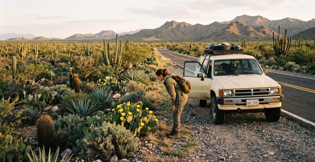
From a moving car, Mexico’s arid scrublands can appear almost featureless. Low grey-green bushes repeat across the landscape, scattered cacti interrupt the horizon, and bare ground seems to stretch endlessly between them. For travellers accustomed to the woodland, lakes and green hills of British national parks, the temptation is to keep driving.
Yet these landscapes are not ecological voids. Their plants conserve water in extraordinary ways, while birds, reptiles, insects and mammals exploit habitats that may be almost invisible through a windscreen. A thorny shrub can provide shade and shelter. A seasonal watercourse can support a denser patch of vegetation. A flowering cactus can attract pollinators to an otherwise quiet-looking stretch of land.
The difference between an apparently lifeless journey and a memorable wildlife encounter often comes down to where you stop, when you look and what you recognise. Understanding those three things turns a routine Mexican road trip into an opportunity to appreciate one of the country’s distinctive ecological landscapes.
Mexico’s scrublands at a glance
- Empty-looking does not mean empty: thorny shrubs, cacti, rocky ground and seasonal drainage channels provide different habitats for drought-adapted species.
- Observation beats distance: a quiet, safely parked stop during cooler daylight hours can reveal more than scanning the landscape from a moving vehicle.
- Safety determines the experience: carry water, avoid exposed midday walks, verify road conditions and keep remote journeys within daylight hours.
- Why Do Mexico’s Arid Scrublands Host More Species Than Most UK National Parks?
- How to Spot Hidden Wildlife in Mexican Scrublands Without Binoculars or a Guide?
- Which Reveals More: A Self-Guided Scrubland Stop or a Guided Desert Walk in Mexico?
- The Scrubland Mistake That Turns A Quick Photo Stop Into a Dehydration Risk
- When Should You Explore Mexican Scrublands to Avoid Peak Heat and See More Wildlife?
- How to Identify 5 Mexican Desert Plant Types on a Roadside Stop Using Shape Alone?
- How to Check if a Mexican Road Is Safe to Drive Before Committing Your Itinerary?
- Why a 100-Mile Drive in Mexico Can Take 4 Hours in One Region and 90 Minutes in Another
Why Do Mexico’s Arid Scrublands Host More Species Than Most UK National Parks?
Mexico’s arid scrublands support remarkable biodiversity because their varied vegetation, rocky terrain and seasonal watercourses create numerous small habitats. However, there is no reliable basis here for claiming that they contain more species than most UK national parks. What makes them surprising is how much biological diversity can remain concealed within a landscape that initially appears sparse.
The central misconception concerns visibility. In a British national park, woodland canopies, green meadows and flowing streams make plant growth immediately recognisable. Mexican scrublands often display far less foliage, yet vegetation cover alone is a poor measure of ecological complexity.
According to CONABIO’s overview of Mexican scrubland ecosystems, these habitats support drought-adapted cacti, agaves, thorny shrubs and numerous animals. Vegetation communities differ considerably between Baja California, Coahuila, Tamaulipas and other regions.
29.7%
Approximate proportion of Mexico classified as scrubland in the historical vegetation figures presented by CONABIO, based on INEGI data from 2005. This is not a newly measured 2026 land-cover estimate.
CONABIO, Matorrales; historical INEGI Series III vegetation classification.
Within these extensive habitats, different species exploit different opportunities. Cacti store water, thorny shrubs provide protected spaces, and seasonal washes can support plants benefiting from intermittent runoff. Rocky outcrops add crevices and thermal differences that matter to small animals.
The animals themselves often avoid easy detection. CONABIO identifies scrubland inhabitants that include coyotes, jackrabbits, roadrunners, owls, lizards and rattlesnakes. These species occur across different regions and communities; their inclusion does not mean every roadside stop contains them all.
Seasonality changes the picture. Following rainfall, plants may produce new growth and flowers, attracting insects and other animals. During prolonged dry periods, surviving vegetation can appear dormant, while wildlife retreats into shade, burrows or less exposed places.
For a traveller, the more productive question is therefore not whether the landscape resembles a familiar national park. It is which organisms have adapted to its particular shortages of water, shade and shelter.
Once the landscape becomes a collection of potential habitats rather than a uniform backdrop, the next challenge is learning how to detect the animals using them.
How to Spot Hidden Wildlife in Mexican Scrublands Without Binoculars or a Guide?
To spot wildlife without equipment, choose a safe stopping place, remain quiet and examine the boundaries between different vegetation types. Look beneath shrubs, around rocky patches and along seasonal drainage channels. Listen before moving, search for tracks or burrows, and favour cooler daylight hours when some desert animals are more active.
The most useful beginner technique is to read the edges. An edge is a transition between habitats: dense bushes beside open ground, a dry watercourse crossing a gravel plain, or a shaded patch beneath a solitary plant.
These transitions offer places to search because animals may use the cover, food or access routes available there. A roadside verge can be an observation point, but its proximity to traffic also makes safe parking essential. Do not assume every wash or fence line is a wildlife hotspot.
Instead of searching endlessly for visible animals, start with clues:
- Burrows: openings in the soil suggest animals use the ground for shelter, although an entrance may be old or unoccupied.
- Tracks: footprints in fine dust can indicate movement, especially where their outlines remain clear.
- Dust-bathing hollows: shallow disturbed patches may reveal where birds have used loose soil.
- Bird calls: sounds can reveal activity even when the birds remain concealed.
- Flower visitors: insects around blooming cacti or shrubs offer a visible glimpse of ecological relationships.
Observation works best when movement is limited. Stand in a permitted, protected area away from traffic, let the surroundings settle and scan slowly. Alternating between listening and looking is often more useful than immediately walking into vegetation.
Timing makes these signs easier to interpret. During early morning or late afternoon, lower-angle sunlight can emphasise shallow footprints and subtle surface textures. Cooler conditions may also encourage activity among species that avoid the hottest part of the day.
The National Park Service‘s explanation of desert ecosystems describes how animals may shelter underground during high temperatures or become active at night. This is general desert ecology evidence from the southwestern United States, not a species-by-species observation schedule for Mexico.
One common mistake is pushing into dense scrub to force an encounter. Doing so may disturb animals, reduce visibility and expose the visitor to thorns or difficult footing. Never approach burrows, handle wildlife or move rocks to reveal concealed animals.
Recognising signs of life independently is rewarding, but some features remain difficult to interpret without local expertise. That is where guided walks can add another dimension.
Which Reveals More: A Self-Guided Scrubland Stop or a Guided Desert Walk in Mexico?
A guided desert walk generally offers more ecological interpretation, particularly when animals are hidden and plant adaptations are difficult to recognise. A self-guided stop provides flexibility, costs less and fits naturally into a road trip. The strongest approach often combines both: short independent observations with a locally knowledgeable guide in a distinctive scrubland region.
Neither option guarantees wildlife sightings. Their difference lies primarily in how much of the landscape a visitor can understand.
On a self-guided stop, observation depends on available time, safe access and the traveller’s ability to recognise clues. You might identify cactus shapes or discover insect activity around flowers, yet overlook the ecological significance of tracks or subtle plant associations.
A knowledgeable guide may explain which species are likely in that particular habitat, distinguish similar tracks, interpret animal calls and identify relationships between vegetation, rainfall and local wildlife.
The comparison becomes clearer when practical constraints are considered.
| Consideration | Self-guided stop | Guided walk |
|---|---|---|
| Itinerary flexibility | High, wherever stopping and access are permitted | Depends on the operator and scheduled excursion |
| Ecological interpretation | Limited by personal knowledge | Can include local species, tracks and habitat relationships |
| Direct excursion cost | Usually no guide fee | Guide or tour fee applies |
| Wildlife encounters | Possible, but not guaranteed | Possible, with better interpretation but no guarantee |
| Safety responsibilities | Visitor manages parking, water, weather and access | Responsibilities can be shared, but the visitor must still prepare |
| Best suited to | Brief observations during a driving day | Focused exploration of a particular ecosystem |
A hybrid itinerary avoids making every stop a formal excursion. Brief roadside observations can introduce the distinctive vegetation of one region. A guided experience later can explain why particular plants grow together, how animals use seasonal water and which conservation concerns affect the habitat.
Choose guides familiar with the specific region, local access rules and safe observation practices. A professional guide should also be clear about the terrain, expected heat, walking distance and required equipment.
The overlooked distinction is logistics. An improvised self-guided stop can become less safe than a planned excursion if parking is unsuitable or visitors leave their water behind. Guided activities may simplify access, but their existence does not remove the need for personal judgement.
Whatever the approach, appreciating the landscape should never depend on taking unnecessary risks. Even a brief stop requires preparation suited to arid conditions.
The Scrubland Mistake That Turns A Quick Photo Stop Into a Dehydration Risk
The mistake is assuming that a five-minute roadside photo stop requires no preparation. Travellers may leave the car without drinking water, sun protection or suitable footwear, then spend longer exploring than intended. In exposed scrubland, heat, low humidity and limited shade can make that casual decision increasingly risky, especially when the vehicle is remote from assistance.
Arid heat is deceptive because sweat may evaporate quickly. A person can be losing fluid without noticing the same damp clothing associated with humid conditions. Direct sunlight and heat from exposed surfaces add to discomfort and physical strain.
Sparse vegetation also changes how distance is perceived. With few obvious landmarks, an interesting cactus or rocky feature may appear closer than it is. A short walk can turn into a longer return across open ground.
The Mojave National Preserve‘s official desert safety advice recommends carrying ample drinking water, using sun protection and avoiding strenuous activity during extreme heat. The guidance also warns that mobile coverage can be unreliable in remote desert areas.
For context, that preserve recommends at least one US gallon, approximately 3.8 litres, of water per person per day for general desert travel, and two gallons for hiking or cycling. These are site-specific recommendations, not universal Mexican requirements; suitable quantities depend on local weather, activity, duration and individual circumstances.
For a roadside stop, the basic preparation should include water accessible to each passenger, a hat, sun protection, closed shoes and a charged phone. Keep the vehicle’s location obvious and do not walk away into unfamiliar country without a proper route and safety plan.
Five checks before leaving the car in Mexican scrubland
- Confirm a lawful, stable parking place: identify a firm stopping area clear of moving traffic, rather than relying on an uncertain shoulder.
- Check drinking water: verify that each passenger has accessible water and that sufficient reserve remains for the onward journey.
- Inspect personal protection: confirm that hats, appropriate footwear and sun protection are ready before anyone gets out.
- Establish an observation boundary: agree on a nearby, visible, permitted area and a return point before beginning.
- Check the exit conditions: confirm vehicle access, remaining daylight, communications and the ability to return safely to the main route.
Parking presents a second hazard. Soft roadside ground can trap tyres, while thorns, stones and concealed drainage features can damage vehicles or cause falls. Never stop on a blind bend, obstruct a roadway or enter a fragile habitat simply to obtain a photograph.
If anyone becomes dizzy, confused, unusually weak or otherwise shows signs of heat illness, stop exertion, move to a cooler safe location and seek appropriate medical help. Confusion, collapse or suspected heatstroke requires emergency assistance.
Once water, shade and parking are accounted for, choosing the right time of day can improve both comfort and the possibility of observing wildlife.
When Should You Explore Mexican Scrublands to Avoid Peak Heat and See More Wildlife?
Early morning is usually the most practical window for exploring Mexican scrublands because temperatures are often lower, light is useful for observation and some animals become active during cooler periods. Late afternoon can offer another opportunity, provided visitors return safely before dark. Seasonal conditions vary across northern deserts, central highlands and coastal scrublands.
There is no single national desert season. Mexico contains multiple arid and semi-arid environments, and their rainfall, elevation and temperature patterns differ.
The scrublands of Baja California cannot be assumed to follow exactly the same seasonal rhythm as those of the central highlands or northeastern Mexico. Before travelling, check climate conditions for the precise region and elevation on the itinerary.
The daily cycle is often easier to apply than a broad seasonal rule:
- Early morning: a favourable period for observing tracks, plant details, birds and animals active before stronger daytime heat.
- Midday: generally better reserved for rest, indoor activities or suitable transfers rather than exposed exploration during hot weather.
- Late afternoon: offers lower-angle light and a chance to observe activity as temperatures decline, but requires a clear daylight return plan.
- Night: some species become active, yet remote wildlife exploration and driving introduce additional hazards and should not be improvised.
Ecologists describe species active primarily around dawn and dusk as crepuscular. This behavioural pattern can reduce exposure to intense daytime heat. Other desert species are nocturnal, while some remain active during the day, so timing should never be treated as a guarantee of sightings.
Rainfall is equally important. A scrubland visited after suitable seasonal rain may display flowers, fresh growth and increased insect activity. The same habitat during a prolonged dry spell may look substantially quieter.
However, recent rain also creates possible access problems. Seasonal washes can flood, and unpaved roads may become difficult or impassable. Ecological interest does not override road or weather safety.
For road-trip planning, use the hottest daylight hours for appropriate longer transfers or sheltered stops, rather than walking across exposed terrain. Schedule nature observation for cooler daylight periods and allow enough time to reach accommodation or a safe destination without night driving on remote roads.
With the timing arranged, the next step is learning to recognise the vegetation itself. Plant shapes provide an accessible introduction even when wildlife remains out of sight.
How to Identify 5 Mexican Desert Plant Types on a Roadside Stop Using Shape Alone?
Five useful scrubland plant forms can be recognised by silhouette: tall columnar cacti, rounded barrel cacti, flat-padded prickly pears, branching thorny shrubs and leafless or nearly leafless succulents. Shape provides a practical first classification without botanical equipment, although it rarely establishes an exact species. Each silhouette also offers clues about water conservation, physical protection or growth conditions.
The aim is not to become a botanist during a roadside break. It is to distinguish broad plant structures, then consider what ecological problems those structures help solve.
Some forms overlap, and different plant families can develop similar shapes under dry conditions. Use the following descriptions as field recognition cues, not definitive species identifications.
| Plant type | Shape to recognise | Ecological adaptation |
|---|---|---|
| Columnar cactus | Tall, upright, often ribbed stems, sometimes branching | Fleshy stems store water; ribs can accommodate changes in stem volume |
| Barrel cactus | Rounded or short cylindrical body with pronounced ribs | Compact, succulent stem provides water storage |
| Prickly pear | Flattened oval or paddle-shaped stem segments | Green pads store water and carry out photosynthesis |
| Thorny shrub | Woody, branching form with small leaves or spines | Small leaves may limit water loss; thorns can discourage herbivores |
| Leafless succulent | Fleshy or green stems with few obvious leaves | Reduced leaf area and specialised stems can help conserve water |
These forms are useful because their structures suggest different responses to scarcity. Succulent plants can store water in specialised tissues. Many shrubs instead rely on root systems, reduced leaves or seasonal leaf loss. Spines may offer protection, and some can also modify the plant’s immediate microenvironment.
Next, look beyond individual plants. Are certain species clustered along a shallow channel? Are shrubs concentrated near rocks? Do cacti stand far apart on exposed ground?
Such patterns can suggest differences in soil, runoff, exposure or competition. They are observations worth investigating rather than proof that water is currently present beneath any particular plant.
The pattern also helps reconnect botany with wildlife. Vegetation provides food, shelter and nesting opportunities, making plant distribution relevant to where animals might appear.
Keep the exercise entirely visual. Cactus spines and the tiny detachable glochids of prickly pears can cause painful injuries, while some other desert plants contain irritating sap. Do not touch, pick, lean against or remove vegetation. Remain on permitted surfaces and avoid trampling plants to obtain a closer photograph.
Recognising the habitat makes roadside exploration more interesting, but reaching those observation points depends on another skill: evaluating the roads before committing to them.
How to Check if a Mexican Road Is Safe to Drive Before Committing Your Itinerary?
Before choosing a Mexican driving route, check current official travel advice, road closures, weather and the condition of any unpaved sections. Assess physical road hazards separately from regional security risks, confirm that the vehicle is suitable, and identify an alternative route. Repeat the checks on the day of travel because conditions can change after the itinerary is planned.
A route that appears straightforward on a map may contain deteriorated surfaces, steep sections, damaged crossings or roads unsuitable for an ordinary hire car. Conversely, a physically good highway may pass through an area where security advice recommends avoiding travel.
These are different questions and both matter:
- Roadworthiness: Is the surface passable? Are there washouts, floods, landslides, loose stones, roadworks or steep gradients?
- Security: Does current official advice identify risks affecting the state, route or type of journey?
- Vehicle suitability: Is the route compatible with the hire vehicle, tyres, ground clearance and rental agreement?
- Journey resilience: Is there enough fuel, water, daylight and a reasonable fallback if the planned route becomes unusable?
For travellers from the UK, current Foreign, Commonwealth & Development Office advice should be part of the security assessment. Mexican government road information, highway operators and official weather alerts can help with route conditions. Mapping applications and recent local reports provide additional context, but should not be treated as definitive proof that a remote road is passable.
The US Department of State‘s Mexico travel advisory, dated 29 May 2026 in the supplied source material, recommends driving between cities during daylight and using toll highways where possible. It also warns that road maintenance varies and mobile coverage can be limited in rural areas.
Its advice is directed primarily at US citizens and does not replace current UK guidance or real-time Mexican road information.
Particularly important is the distinction between paved highways and unpaved approaches. A destination may be accessible by a major road for most of the journey, followed by a difficult final stretch that changes the entire risk assessment.
Check that final stretch before departure. If conditions cannot be verified or the vehicle is unsuitable, choose another accessible observation site rather than attempting the route.
Rainfall can make dry washes unexpectedly hazardous. Never drive through floodwater, and do not enter unmarked tracks merely because a navigation application displays them as a route.
Once the route is considered suitable, the remaining challenge is estimating how long it will actually take. Mexican road distances alone provide a surprisingly incomplete answer.
Before estimating your driving day
- Check whether the planned route follows a toll motorway, an ordinary highway or an unpaved access road; the distance alone is insufficient.
- Reserve the largest time margins for mountainous terrain, frequent town crossings and uncertain road conditions.
- Fit scrubland observation into safe daylight windows without allowing a delayed arrival to force remote driving after dark.
Why a 100-Mile Drive in Mexico Can Take 4 Hours in One Region and 90 Minutes in Another
A 100-mile journey in Mexico can take very different amounts of time because average speed depends on terrain, road design, town crossings and surface conditions. A fast, uninterrupted motorway journey may take around 90 minutes, while a winding route with slower sections can take four hours or more. These are illustrative scenarios, not verified times for specific Mexican routes.
For travellers accustomed to planning British motorway journeys by mileage, this variability can be easy to underestimate. The main difference is that Mexico’s road network connects diverse landscapes, from relatively flat highways to mountainous roads and remote unpaved routes.
Three structural factors explain much of the variation.
- Terrain: mountain roads may require repeated acceleration, braking and careful navigation around bends, reducing average speed.
- Road classification: controlled-access toll highways, ordinary federal roads and unpaved routes offer very different driving conditions.
- Settlements and traffic controls: town traffic, junctions and topes—speed bumps—can interrupt progress even when the road itself is paved.
Consider an explicitly hypothetical comparison involving two journeys of 100 miles, approximately 161 kilometres.
Illustrative journey-time comparison
Route A follows a relatively direct, high-speed road with few interruptions. If the overall average speed is approximately 107 km/h, the 161 km journey takes around 90 minutes.
Route B includes winding sections, towns and lower-speed roads. At an overall average of approximately 40 km/h, the same distance takes roughly four hours.
These arithmetic examples explain how road characteristics affect travel time. They do not establish actual speeds, legal limits or safe journey durations on any particular road in Mexico.
The planning consequence is clear: estimate by route and conditions, not just mileage. Use realistic navigation estimates, review the road categories along the journey and allow additional time where the route leaves major highways.
Such flexibility also benefits wildlife observation. A planned stop becomes a positive part of the journey instead of an interruption that jeopardises the arrival time. Short observation periods can be scheduled without rushing, particularly in the cooler morning.
The reverse is equally important. A slow or delayed road journey should never encourage squeezing in one more scrubland excursion as darkness approaches. Reaching a safe destination takes precedence over an optional stop.
A practical daily sequence is to start with a brief, safe morning observation, complete suitable longer transfers through the middle of the day, and consider another stop only if conditions and remaining daylight genuinely allow it.
On the next Mexican road trip, identify one suitable scrubland viewing opportunity in advance. Check the route and forecast, prepare for the heat, and allow time to observe without leaving a safe permitted area. A few careful minutes spent looking at shrubs, cacti and the traces of hidden animals can transform the way the landscape is understood.
Is Mexican scrubland the same as a desert?
Not exactly. Scrubland refers to vegetation dominated by shrubs and related plant communities, whereas desert classification primarily concerns arid environmental conditions. Mexican scrublands occur across arid and semi-arid regions, with different rainfall patterns, plant structures and species. The terms can overlap, but they are not interchangeable in every location.
Can you see wildlife in Mexican scrublands without entering the vegetation?
Yes. Observing from a safe, permitted roadside viewing area can reveal birds, insects, flowering plants, tracks and burrows. Wildlife may remain concealed, especially during hot conditions, but visible animals are not the only evidence of ecological activity. Avoid entering dense or fragile vegetation unnecessarily.
Are rattlesnakes common at every Mexican scrubland stop?
Rattlesnakes occur in Mexican scrubland environments, but their presence and abundance vary by region, species and habitat. An individual roadside location cannot be assumed to contain them. Wear appropriate footwear, watch where you step, never place hands into concealed spaces and leave any snake undisturbed.
Should travellers visit Mexican scrublands immediately after rainfall?
Rainfall can encourage plant growth, flowering and insect activity, making the landscape interesting to observe. However, recent rain may also cause flooding, soft ground or damaged access roads. Check current weather and route conditions before setting out, and never enter flooded washes or uncertain unpaved tracks.
Do you need a four-wheel-drive vehicle to appreciate Mexican scrublands?
Not necessarily. Some scrubland scenery can be appreciated from paved roads, designated viewpoints and accessible visitor areas. A four-wheel-drive vehicle is not automatically necessary or sufficient for remote access. Any excursion beyond paved roads requires checking local conditions, permissions, vehicle suitability and rental restrictions before travelling.